In the middle of August, we came back to Cornwall for about a week to go to my grandfather’s memorial. We also used the plentiful time, resources, and space to do some trail-related projects, like:
dehydrating some food, like pasta and tomato sauce (below, dgenna takes a tray of dried tomato sauce out of the dehydrator);

for dgenna, making a new, very geometric rain hat;

and for me, finally buying some new Superfeet insoles to replace the ones I’d been wearing since Georgia.

We returned to the trail in late August, with the understanding that we were going to keep hiking north until it got too cold. We were near Dalton, MA, a flattish, pretty section in northern Massachusetts, and the trees were still green, the days still very warm, but the evenings were coming noticeably earlier. In Virginia, we’d often hiked until 7 or 7:30 pm, but now, after a few nights getting caught setting up camp after dark, we began to start looking for a campsite around 6.

For all long-distance hikers: I highly recommend having a hiking partner whose hair is long enough to french braid. Out in the woods you have to make your own entertainment.

However, the first couple weeks on the trail weren’t easy. Gore Pond, above, was a gorgeous place to visit for any reason: trees starting to change around the edges of the swamps, conical beaver den in the middle of the pond (right behind the largest dead tree in the photo). However, unfortunately we spent two nights there because dgenna was too sick to move–chilly, feverish, and very low energy. Over the next few days, dgenna was able to hike, but not more than a few miles each day and not without expending way more energy than was usual. The symptoms ebbed and flowed, but never completely went away. We meandered our way through northern Massachusetts, into Southern Vermont, but it was clear that something was not right and we eventually realized that we were going to have to go to a doctor.
The option with the best hours and the highest likelihood to take dgenna’s insurance was the hospital in Bennington, VT, where, amazingly enough, I never went during my four years of college there. They didn’t take a blood test, but diagnosed dgenna with Lyme Disease, as we’d both suspected, based on “weird symptoms” + “four months living outside on the East Coast.”
We spent the night at the extremely hospitable Catamount Motel, waiting for the pharmacy to open in the morning. Three awesome things about this nondescript little motel in Bennington:
- When I called to ask if they had a washing machine, they answered, “Are you a thruhiker?”
- They actually let us use the washing machine (in the basement, not for the use of regular customers, but completely effective).
- First we got a 10% hiker discount–then we actually rented the $50 “hiker room”, a totally normal motel room, which customers don’t usually rent due to its minor wall scuffs and dent in the door. (The owners know that if it’s clean, with four walls, a bed, and a shower, it will rate as “fancy hotel” to most hikers.) More than we’d spend on a hostel, but much, much less than we expected for a last-minute room.
And, to the great relief of us both, the antibiotics worked. We’d heard stories of hikers needing to leave the trail to recuperate from Lyme, and were grateful that we got lucky.

Moonrise from a shelter on the way up Mt. Greylock.
As we chugged along through northern Massachusetts, we came to Mt. Greylock, the highest peak in the state and a great view on a clear day. Although Greylock is very near the border of Vermont, we had been able to see it from Jug End on the other side of Massachusetts, almost 90 miles away.

A mysterious cabin on the mountaintop pond less than a mile from the summit of Greylock.

Some other visitors (not us) enjoy the view east.
Even though at this point in the trip, we were still moving slowly, uncertainly, and worriedly due to dgenna’s untreated Lyme, we still had amazing experiences, like this gem of a campsite on a west-facing ridge.


We knew that several hiking friends of ours had “flip-flopped,” and were looking forward to meeting them again as we headed north and they headed south. Flip-flopping is a hiking term that means hiking from Georgia to a point in the middle of the trail (often Harper’s Ferry), then hiking from Maine back to that point in the middle, instead of thruhiking northbound or southbound. Thruhikers who want a longer hiking season often do this.
Just before crossing the MA/VT border, we met a friend of ours who had flip-flopped, Birdie! We’d always liked overlapping with Birdie, whom we last saw in Pearisburg, VA, where we went to a Mexican restaurant with her and her brother to watch the US-Portugal World Cup game that started our soccerblazing phase. We had no idea where she was–then suddenly, she was hiking down the trail towards us! During the hot Virginia summer she sometimes wore ferns tucked behind her ears to automatically wave mosquitoes away from her face, so this time I wasn’t too surprised to see her wearing a beautiful goldenrod crown. We shared a box of ginger cookies that dgenna had very sneakily bought during our last resupply. 

Above, dgenna climbs the last steep hill in Massachusetts. We hadn’t gotten to the White Mountains yet, so trails made of steep piles of rock were still a novelty. Soon after we entered Vermont, we were able to hitchhike into Bennington, where dgenna got treated for Lyme. On the way out of Bennington, we decided to take a trail that led directly from town to Glastenbury Mountain, instead of hitchhiking back to the AT and continuing to the same place. This trail proved a bit hard to find–marked only by a single blue blaze on the side of a small road–and led us out of town through the recovering scrub land around the highway. As we went through the underpass, the “light at the end of the tunnel” became more literal than ever before.

That day, September 8, we celebrated our five-month trail anniversary as well as our first year anniversary as a couple. It was a pretty remarkable trail for the occasion: starting in Bennington, hiking out of town under the highway, up into the mountains, where the trail got really beautiful and we got our first inklings of how incredibly spectacular Vermont was going to be.

Here’s the thing about Vermont. Each state that we hiked through had its beauty. Many long-distance hikers hike in order to reach these places of beauty, like big open views, and wait for them eagerly as they hike the less spectacular parts of the trail. But in Vermont, you’re not waiting for anything–although the 150 miles of Appalachian Trail in the state certainly has its share of big views, the entire trail is so beautiful that simply looking at the trail ahead of you is as stunning as reaching the top of a mountain. The photo above isn’t an anomaly–anyone who enjoys sweet-smelling forests of spruce and fir, moss so thick you can sink your whole hand into it, and miles of paths in deep, peaceful woods will probably love Vermont.
As long as you aren’t there in the mud season. We had a dry summer. Thanks, weather!

The trail also passes by many swamps and wetlands in Vermont, so we often saw lush swamp moss like this.

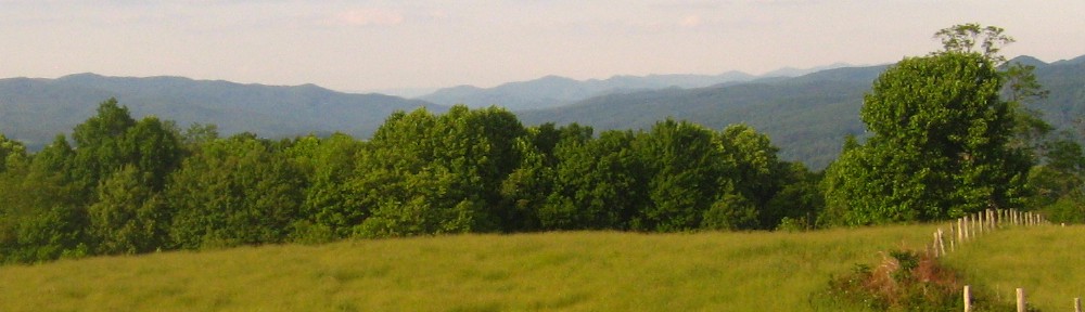
Above: looking south from the top of Big Bald Mountain on the way out of Bennington. We were officially in the Green Mountains. Entering the Green Mountains is particularly exciting for northbound thruhikers–it’s the first time they’ve been in mountains above 3,000 feet since Virginia. Although we hadn’t hiked the entire trail in between the two places, we shared the excitement of being surrounded by big mountains again.

Many trees along the way seem to have outgrown the need to be in soil! (Just kidding, they probably grew on top of stumps that have long since rotted away.)
 Above: the fire tower on Glastenbury Mountain, no longer in use by fire wardens but still standing and open to hikers. Vermont has several of these. We were there on a clear day and had spectacular 360 degree views!


Looking straight down off the fire tower to our packs in the clearing below.
We forgot to get denatured alcohol for our stove in Bennington, meaning that we had to stop even earlier to make cooking fires. However, dgenna’s experience cooking outdoors every day at Salamander Springs came in handy…


We reached the top of Stratton Mountain as a cloud moved in: by the time we climbed the fire tower, the photo above was all we could see. Not quite what we’d expected, but otherworldly! We stayed there a while to see if it would pass, but it only got cloudier and colder. Before long, it was clear that a rainstorm was there to stay. We moved on and hastily made camp. Little did we know that a long-lost hiking friend would surprise us the next morning….but that’s a story for another blog post.
Until later, and sending love from both of us to everyone reading this,
-Hannah

I just love reading about your adventure! All best from Terry & Carolyn.
LikeLike
Thanks so much! Glad to hear you like it. Happy Thanksgiving! -Hannah
LikeLike